
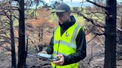
Thermal Drone Wildfire Detection in the Cairngorms
It is 06:00 on a freezing autumn morning in the Cairngorms National Park, and the silence across the Scottish Highlands is absolute. Light is only just beginning to fracture the horizon, casting a cold gray wash over miles of charred pine and scarred earth. Three months ago, a massive blaze tore through this landscape, burning across 3,300 hectares of protected moorland and ancient forest. Looking across the tree line today, you would swear the danger had passed. The flames are gone. The sky is clear. No massive plumes of smoke mark the horizon. Yet, beneath our boots, the ground is literally cooking.
Thermal drone wildfire detection uses high-resolution long-wave infrared (LWIR) radiometric sensors mounted on uncrewed aerial vehicles to detect hidden heat anomalies beneath the forest floor. By pinpointing underground smoldering hotspots invisible to the human eye, this technology allows ground crews to douse subterranean embers before they reignite surface blazes.<\/p>
- Subsurface Threat Elimination: Thermal drones detect subterranean hotspots burning beneath peat and root systems months after surface flames are extinguished.
- Targeted Resource Deployment: Conservation groups like the RSPB use precise GPS coordinates from aerial thermal surveys to deploy limited ground crews efficiently.
- Long-Term Ecological Tracking: Automated drone waypoints provide month-over-month imagery to monitor flora recovery and habitat regeneration across burned terrain.
Standing on a damp access track, drone pilot Pete Short unpacks a compact quadcopter equipped with high-resolution radiometric optics. His daily mission is simple but grueling: execute dawn patrols using advanced thermal drone wildfire detection to search for underground fires that cannot be seen, smelled, or tracked from the ground until it is far too late.
The Ghost Fires Burning Beneath the Peat
Smoldering fires are the quiet killers of the Scottish peatlands. While active blazes capture headlines with towering walls of flame and dramatic water-drop operations, subterranean combustion poses a sneaky, long-term threat to ecosystem survival. When fire sweeps over dry heath and pinewood, it does not merely consume surface brush. It travels downward into the duff—a dense, carbon-rich layer of decaying pine needles, moss, and peat accumulated over centuries.
“Every week I hope that I find none,” Short remarks, his fingers adjusting the flight controls as the drone ascends into the mist. “On the last thermal flight I did, we found eight separate hot spots. Without this gear, we would be completely blind.”
Minutes into the flight, the drone’s display flashes. Amidst the dark blues and purples representing the freezing Scottish soil, a sharp, white-hot pixel cluster emerges beneath a stand of scorched Scots pine. The system registers a ground temperature far exceeding ambient levels. There is no visible smoke from our vantage point, nor any ash drifting in the air. Yet, the thermal camera indicates a hidden engine of combustion churning beneath the tree roots.
“Without the thermal technology, we would be totally blind to this. You can stand right on top of a subterranean fire and have no idea it exists until the ground collapses or a gust of wind sparks a fresh surface wildfire.”
Equipped with coordinates generated by the drone’s onboard positioning system, we trek through the soot-stained forest toward the site. To the untrained eye, the ground looks cold and undisturbed. But as Short bends down and scoops away a thin layer of topsoil, a pocket of trapped heat escapes. Within seconds, thick white smoke rushes out into the cold air. A stone pulled directly from the earth feels hot to the touch. This hot spot has been burning continuously since mid-July, insulated beneath the earth like charcoal in a furnace.
The Physics of Infrared Precision Scouting
How do uncrewed aircraft spot heat trapped deep underground? The answer lies in radiometric long-wave infrared (LWIR) sensors. Unlike standard cameras that record visible light, thermal sensors capture electromagnetic radiation in the 8 to 14-micrometer wavelength band. Every object emits infrared energy based on its temperature. When subsurface peat smolders, heat moves upward through thermal conduction, creating a distinct localized temperature gradient on the surface soil above it.
During the height of the July emergency, five elite drone operators were deployed to coordinate aerial intelligence alongside ground crews and firefighting helicopters. Navigating that environment was high-stress work: dense smoke columns blocked vision, rapid wind shifts threatened small aircraft, and low-flying water bombers shared the tight airspace. Today’s reconnaissance work requires a different kind of precision.
Key System Capabilities in Subsurface Fire Detection
- Radiometric Pixel Measurement: Allows operators to read exact surface temperatures remotely in real time, filtering out harmless thermal noise like sun-warmed rocks.
- Automated Grid Mapping: Enables systematic scanning of large acreage without missing hidden patches between flight paths.
- Dual-Sensor Visual Overlays: Blends optical and thermal feeds so pilots can instantly cross-reference heat signatures against physical landmarks.
- Precise Spatial Tagging: Generates immediate GPS waypoints for ground crews, reducing search times across difficult terrain.
For land management agencies operating on tight budgets, this level of precision changes everything. Data gathered by thermal equipment feeds directly to field units, saving dozens of manual search hours across vast wilderness areas.
Targeted Interventions: Resource Allocation in Vulnerable Reserves
Managing post-wildfire recovery across thousands of hectares is an immense logistical headache. Ben Jones, senior site manager for the Royal Society for the Protection of Birds (RSPB) at the Abernethy reserve, emphasizes that precision data is key to protecting remaining habitats.
“We’ve been fighting this fire for months now, and our ground teams are stretched thin,” Jones explains. “You simply cannot send personnel to march blindly through thousands of acres of rough terrain hoping to stumble upon a fire. We need exact coordinates. Drones give us the ability to drop teams right on top of the problem so they can dig out the ember and douse it with water before it spreads.”
The threat is far from theoretical. Even as autumn brings damp weather and freezing temperatures to the Highlands, underground fires can survive persistent rain. The dense canopy often deflects light rainfall, while the hydrophobic nature of dry, burnt peat causes water to run off the surface rather than penetrating down to the burning core. If an unextinguished hotspot reaches a pocket of dry, unburnt roots during a windy day, it can breach the surface and ignite a fresh wall of flame.
Comparative Analysis: Scouting Paradigms
To understand the leap forward that non-line-of-sight thermal monitoring represents, consider how post-wildfire monitoring was handled before uncrewed aerial systems were deployed at scale:
| Operational Metric | Traditional Foot Patrol Scouting | Thermal Drone Aerial Surveys |
|---|---|---|
| Coverage Rate | 5–10 hectares per day per team | 200+ hectares per day per operator |
| Detection Capabilities | Surface smoke and visible flames only | Subsurface thermal anomalies (10–50 cm deep) |
| Terrain Constraints | Limited by cliffs, bogs, and dense brush | Unaffected by surface terrain obstacles |
| Coordinate Accuracy | Approximate visual estimation | Sub-meter GPS pinpointing |
| Personnel Risk Profile | High (footing hazards, fall risks, ash pits) | Low (remote operation from safe vantage points) |
Ecological Resilience and Digital Twin Evolution
Beyond immediate hazard mitigation, these thermal aircraft are taking on a vital second role: tracking ecological recovery. Dr. Sarah Henshall, head of conservation at the Cairngorms National Park Authority, emphasizes that understanding long-term habitat recovery requires precise, repeatable scientific data.
To build this baseline, Short programs his flight computer to follow identical, automated flight paths month after month. By locking in precise waypoints, altitude settings, and camera angles, the team can assemble a high-resolution visual time-lapse of the park’s recovery over years—and even decades.
Walking through the burn zone reveals early signs of life amidst the devastation. Blackened trunks stand against new life breaking through the soil: bright green mosses, vibrant fungi, and tiny yellow wildflowers sprouting through ash-rich topsoil. Industry research tracked by Reuters suggests that integrating continuous spatial monitoring with environmental conservation helps land managers identify invasive species threats and soil erosion risks far earlier than traditional ground sampling allowed.
“Some ecological recovery will happen quickly; other processes will take decades or outlive us entirely,” notes Dr. Henshall. “By flying identical drone routes year after year, we are creating an archive of photographic data that reveals exactly how native woodlands heal themselves after severe disturbance.”
Early Warning Networks: The Next Frontier in Wildfire Prevention
The lesson of the Cairngorms wildfire is clear: waiting for a plume of smoke to appear above the forest canopy means you are already behind the curve. As regional weather patterns become more volatile and extended dry spells hit high-latitude environments, land managers across Europe are looking to turn seasonal response drones into permanent early warning networks.
Future deployments aim to feature automated drone stations—commonly called “drone-in-a-box” systems—powered by local solar and wind chargers. These autonomous craft can launch on scheduled thermal patrols whenever fire danger ratings spike, scanning thousands of acres without requiring a human pilot on site. Algorithms trained on thermal data can automatically flag surface temperature spikes, alerting ranger stations in minutes.
Back on the ground in Abernethy, Short brings the quadcopter down for a battery swap. The morning patrol has logged two new thermal anomalies buried beneath deep root systems. Coordinates are logged, radio messages sent, and ground crews are already en route with pumps and hand tools. Beneath our feet, the ground may still be burning, but up in the sky, technology is ensuring the fire has nowhere left to hide.
<button type="button" onclick="this.parentElement.innerHTML='✓ Thank you, we will refine our analysis!‘” style=”background:#ffffff; border:1px solid #cbd5e1; border-radius:6px; padding:4px 12px; font-size:12px; cursor:pointer; color:#334155;”>👎 No
